
The dangers of travellers developing an over-reliance on GPS navigation systems has been highlighted once again by another terrifying Outback ordeal.
Two German tourists are lucky to be alive after their vehicle became bogged when Google Maps gave them a bum steer in Queensland while they were attempting to travel from Cairns to Bamaga.
After leaving Cairns on February 4, the duo were directed to enter Oyala Thumotang National Park and to follow an old dirt track known as Langi Track, which leads to the old Archers Crossing.
Two days later, their four-wheel drive became bogged, and they were unable to shift it. Due to their remote location, there was no mobile service or internet connection.
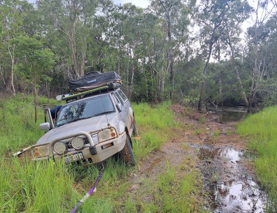
Going nowhere! The tourists' vehicle got horribly bogged. PIC: QPWS
Incredibly, the pair survived, and stumbled into Coen a week later when they alerted authorities to their ordeal. They had walked about 60 kilometres carrying 12kg backpacks, and used a drone to help find nearby roads.
“It’s very hard to get out of there, because we walked for 22 hours and for older people it would be very hard because they’re not very fit,” said one of the travellers, Marcel Schoene. “When we were walking to Coen, it was too hot in the midday, so we can’t walk then so we had to take a break.”
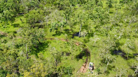
The German travellers were stuck in seriously remote country. PIC: DES
The other German tourist, Philipp Maier, said Google Maps had advised them to go to the national park right away.
“And we thought just do it because maybe the main road is closed because of a high river,” he said. “At Box Creek where we got stuck, it looks really dry … the surface was dry but under the surface it was really wet and muddy, almost impossible to get out of there.”
Ranger in charge Roger James said the whole adventure could have ended very differently.
“National parks in Cape York can be unforgiving, and people need to ensure they have all the survival essentials, and they must be prepared for a stranding incident,” he said. “These men tried crossing a river on a fallen log, endured intense heat and storms, encountered cattle, pigs and crocodiles and had to sleep in the bush … this incident could’ve ended tragically.”
Rangers later assisted the local mechanic in retrieving the tourists’ car.
“These men ended up on foot in oppressive conditions and although they had supplies and a shelter for sleeping, they are extremely lucky to be alive,” Mr James said. “This is not the first incident of Google Maps sending people off the Peninsula Development Road and into national parks, where they either get lost or their vehicles get bogged … people should not trust Google Maps when they’re travelling in remote regions of Queensland.”
He said travellers needed to follow the signs, use official maps or other navigational devices.
 WIN! WIN! WIN!
Grey Nomad Members now have the opportunity to win an Engel MT-V45F 40-litre portable fridge-freezer. The MT-V Series has the advantage of 12 volt, 24 volt and 240 volt operation built into the unit, as well as automatic AC/DC changeover. This robust appliance, valued at $1,499, has robust corner protectors and handles, larger lockable door latch for ease of access, stronger reinforced basket.
Click here to find out more about GN membership, the prize, and how to enter.
Members: If you wish to enter, please click here.


Heck no! Google Maps gives us a bum steer every now and then when we’re close to major towns, let alone in the Outback!
I would use Hema Maps. Digital and printed.
Agree would not trust google in any instance let alone in national parks
Have hema + hard copy 4wd drive tracks.
Google cannot even get streets correct inthe suburbs.
We always have paper maps with us, especially when going Out Back, and even they are not 100% accurate at times.
Reminds me of Michael on “TheOffice” when google maps directed him to drive through the lake…. google maps said it , so it must be right! 😉
Smart people do not use Google Maps …. never accurate. Best to use paper maps and local knowledge. AND, never travel in Australian Outback and the like alone … go:in a convoy
Dead right on that comment.
Google maps and Waze are not designed to be offline navigation apps and therefore cannot replace the likes of ExplorOz traveller and Hema explorer. Google plots the route when it has cellular or WiFi coverage and takes into account reported route closures due to i.e. flooding, fallen tree on road, accidents. As soon as the phone/tablet leaves the cellular or WiFi coverage, it relies on the map section with plotted route it stored before and will not correct it until it detects cellular or WiFi coverage again which can be a day or more later.
Apps like ExplorOz and Hema can store the full range of AUS topo maps, hence replacing a few kgs of paper maps.
That means that if your plotted route is blocked or you become bogged, you will be able to plot a new route to the nearest town or main road only relying on the builtin GPS receiver of your phone/tablet and will not have to wonder around in the bush for days.
As a general rule, never venture into the outback without a Sat phone or at least a PLB. Never rely on your smartphone in a country like AUS where cellular systems only cover 30% of the total area. This is something visitors from highly populated countries find hard to believe.
Agree DON’T use google there are fare better options
I’ve been redirected the wrong way even in a full roaded area. We were testing out the new navman, knew where we were going but maps wanted to send us about 20k long way around. We always carry paper maps as well
If you really plan to go bush, make sure you have a set of updated paper maps with you just in case you arrive at an intersection with 2 tracks going to the left, 3 straight ahead and 3 to the right and you get a message: ‘GPS signal lost’. You will not be able to see on your nav app where you are and which direction to go. This can easily happen on a cloudy day when the cloud cover is quite thick.
Never trust google maps! In Cape Town if you use it to drive from the airport it leads you into badlands and you can get yourself killed ! Terrible
Personally, with all the rain we have had and 2, albeit small, cyclones this year, I wouldn’t travel anywhere north of Cooktown yet and certainly not with just one vehicle. Had they had another vehicle following them a certain distance at least they could have headed back ! I’d rather be humble and prepare a bit more meticulously for Cape York
Aside from relying on Google Maps, I would have to question their common sense regarding travelling to Cape York during the wet season, especially with the rain that has occurred up their this year.
Any person or persons travelling throughout Australia should prepare for the trip prior to leaving
One of the most important items you carry is an military map it has the details you require
I wouldn’t at any time rely on any other device when travelling throughout remote areas
Also the local police in the areas are a good contact
No way I would trust Google maps. I have a Hema app, and I would carry a satellite communicator for emergencies
There are a multitude of reasons why anyone, no matter how experienced, can get stranded. Even a few kilometres off the main highway can be deadly. Mapping is just one contributing factor. It never ceases to amaze me that people can spend $100k+ on a 4WD with all the accessories, but not spend $350 on a PLB(connected to Canberra AMSA, not an overseas interception centre with no service guarantee) Just flick the On switch, and stay put. Is it not that simple ?
Well really, how pathetically stupid are the two of them to even try and traverse the northern parts of Queensland during the ‘wet’ and in particular after one of the wettest periods in decades. I’m sure lots of people would have advised them not to go and it’s on fb, road reports, travel blogs, you name it and the warnings are out there. DO NOT travel Cape York during the wet.
The roads were closed but still they wanted to push on. So then they get stuck and now everyone in Australia wants to blame Google Maps. They should be ashamed of themselves.
Would I trust Google Maps? I take it with a pinch of salt.
The two tourists were planning to travel from Cooktown to Bamaga on the Provincial Development Road (PDR) which is the main travel route through the Cape York peninsula. If you stay on this road at any season of the year and obey the Road Closed/Open signs you should be able to travel all the way without any map. Looks like Google ignores road conditions in NPs during the wet season. Travellers often don’t bother to check road conditions before heading into the outback which would have saved them from getting bogged even if they used a digital or paper map.
On a trip to Western Victoria recently with an i phone and internal gps at a T intersection one said turn left, the other said turn right. With no dire consequences as we knew the road a coin toss solved the problem.After travelling Darwin Sydney return 16 times on all the alternative routes the antiquated NRMA strip maps solved all problems previous to satnav wizardry.