Recent wild weather means that one of the most popular grey nomad destinations in Central Australia will stay off-limits to tourists for the foreseeable future.
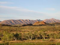
Ellery Creek Big Hole in the West MacDonnell Ranges will stay a no-go zone for travellers as heavy rains have caused significant and extensive damage to the access road.
Works to upgrade the two-kilometre access road started back in December and had been expected to finish late last month … before Mother Nature had her say.
Crews have only been able to access the site to assess the damage in the past week and regional director from the Department of Planning and Infrastructure, May Taylor, said it had been disappointing given the progress the contractors had made.
“We’re working with the contractor to assess the damage and to develop a plan to progress the works as soon as possible,” she told the ABC. “We will come up with a plan to get works back on track, but at this stage I am unable to give any sort of timeframe of when that will be.”
Ms Taylor said the damage was extensive.
“In some places, particularly across the river, it’s hard to distinguish between the road and the actual riverbed,” she said. “It’s a bit hard to see where the actual road is.”
She said that the contractors had been putting some finishing touches in a couple of areas before the rain came, ‘and now we’re back to square one’.
Heavy plant and equipment stored at the site was also damaged.

Sand covers the river crossing at Ellery Creek. PIC: NT Government / ABC
“The extent of the floodwaters that came down the Hugh River has seen some of that plant equipment actually go underwater,” Ms Taylor told the ABC. “Obviously you need some of that key equipment to be able to progress.”
Parks and Wildlife operations senior director Chris Day told the ABC that it had been a significant flood for the region.
“The entire Finke River catchment was affected,” he said. “It was probably the biggest flow since Easter, 2000.”
Mr Day said they were expecting significant damage to the campsite north of Ellery Creek, which formed part of the Larapinta Trail.
“We have an automatic rain gauge at Mt Sonder. This recorded 112mm from January 27 to 31,” he said. “Then a further 114.8mm to February 3.”