
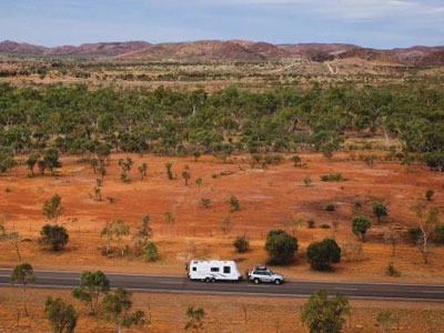
Google has been accused of inflating Outback drive times. PIC: Tourism and Events Queensland
With Outback communities desperate to attract grey nomads and others to visit, Google Maps is being accused of frightening away tourists.
Critics of the app say it has inflated many travel times in remote areas, sometimes adding up to six hours to journeys … and that is certainly not helping to persuade more people to make the trip out.
One particular drastic example was the trip from Birdsville, on the Queensland border, up to the Western Star Hotel in Windorah. Google Maps first had the trip, a 380-kilometre journey, listed as taking close to 11 hours. After the company was contacted about the inflated hours, Google dropped the travel time to seven hours, 49 minutes. While less extreme, the quoted travel time would still leave the driver doing around 50km/h the entire trip.
The Queensland Government is now getting involved, with Acting premier Cameron Dick saying he will be writing to the head of Google Australia and New Zealand, Mel Silva, asking her to fast-track amendments of the travel times,
“We are so dependent on those apps now to get us around cities, to get us around towns, and to get us around big states like Queensland and we need to ensure those apps and the information they are providing are as accurate as possible,” he told ABC radio.
Outback Queensland Tourism Association General Manager Peter Homan told the ABC that those planning an Outback trip should steer clear of Google Maps until the problem is fixed, and head straight to the source of local knowledge.
“Every shire has a Visitor Information Centre, with the best information about travel times, what’s going on in the local area, distances, the best watering holes, where to catch fish,” he told AAP. “They can just give them a call, and they’re also full of local characters so they’ll have a good yarn, too.”
Mr Homan said tourism was crucial for outback towns struggling with drought, which is entering its eighth year in some regions.
“It’s incredibly important; it’s the industry that’s keeping a lot of the local communities together,” he said. “It’s more than money coming into their towns, it gives retailers an opportunity to sell their products, it’s giving people pride in their towns.”


Google definitely has a problem. .I have travelled extensively throughout Aus and the inaccuracy occurs often. Having used some roads more than once, I know that the times and distances given are ridiculous. For instance if I know I am 50ks or so from my destination Google may tell me that I have much further to go and will arrive in 3 or 4 hours !! This does occur quite regularly regardless of where I am.
I find this article interesting, especially as my wife and I did a Central Australia trip some months ago. We were in a 4WD, not towing. When I checked Google Maps for the time to travel from Coober Pedy to William Creek I received an estimate of some 6.5 hours. The road is a little rough but nothing too bad. We did it in around 1.5 to 2 hours in each direction.
Forget Google…buy a decent up to date map…forward plan your distances a few days ahead, paying attention to alternative routes.
As a back up install a Hema navigator. Ninety percent of my journeys are bush and isolated trips…never had an error with my bearings or distances.
you could use whereis
My Husband and I drove the mining road from Hyden to Norseman last week. Google maps quoted 9 hours and 34 minutes driving time. We did it in a tad over 3 hours and kept under the speed limit all the way plus stopped a couple of times for the road crew to go through that was grading the road.
Hi Barbara, my wife and I are driving over to NSW in early July, considering the Hyden – Norseman route you mentioned to cut the Esperance corner off. We have a Diesel Ford Territory AWD, did you find road conditions OK. I have looked at it using Google maps/earth, appears ok in most places, did you face any problems and what were you driving.
If these so called wrong times were worst case scenario the times would be a damn site longer, it’s only an estimate for gods sake use your brains instead of relying on a program.
To use our brains instead of an app, or some other kind of assistance, would require foreknowledge of the road and conditions. I, for one, did indeed attempt to acquire that information before the trip but, being unable to do so, relied on the only source available to me. The fact that it was wrong by a factor of at least three doesn’t change anything. In future I will continue to use Google maps for much of my navigation but will be wary of any time estimates for unsealed roads. Incidentally, the 6.5 hours estimate for the William Creek Road would have to be a worst case scenario because it’s inconceivable that the trip would take anyone (other than someone on a pushbike) anywhere near that long, even if the road was in extremely poor condition. So in this instance your opening statement is way over the top.