
The dangers of an over-reliance on navigation apps when driving in the Outback have been graphically illustrated once again after a young nurse became stranded in the Central Australian desert without food or water.
The 22-year-old was driving solo from Alice Springs to the Harts Range rodeo a week or so ago, when Google Maps led her in the wrong direction.
The ABC reports that, instead of going on the Stuart Highway, she was directed up the Ross Highway, and across the rough dirt tracks and paddocks of the remote Ambalindum cattle station.
Luckily, after her car ended up in a ditch, the nurse managed to send an SOS text via her mobile to summon help.
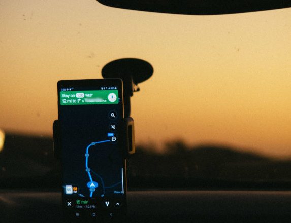
Proceed with caution! PIC: Athena / Pexels
She later discovered Google Maps was directing her to the actual ranges, not the community of Harts Range itself, where the rodeo is held.
Senior Sergeant Michael Potts, from Alice Springs Police, was involved in the rescue effort. He told the ABC it was very lucky the nurse had a new phone model, which could link up to satellite systems to provide an SOS function.
Senior Sergeant Potts said the young lady had needed to search for the Harts Range Racecourse, or ‘Atitjere’ — the Aboriginal name for Harts Range — to be directed to the rodeo.
“This is an easy trap for a lot of people to fall into, which happens quite often,” he said.
Police say that, before travelling in the Outback, people should ensure they had a satellite phone, personal locator beacon (PLB), or emergency position indicating radio beacon (EPIRB) on hand.
Google told the ABC it was looking into the naming of Atitjere and the two locations known as Harts Range.
“We use a variety of sources to get the most accurate and up-to-date information on the map, and we use a combination of manual and automated techniques to check for accuracy,” a spokesperson said. “When there’s an issue, we work to fix it as quickly as we can.”
Of course, many Outback travellers have also been caught out when using GPS.
Grey nomad Jennifer Mays says she was camped at Wulgumerang in Victoria (north of Buchan and Gelantipy) last Christmas when two backpackers who had been heading for Jindabyne and following their GPS arrived at the camp
“The road north from Wulgumerang is a single-lane goat track!” she said. “And then the next day a young couple towing a 20’ caravan pulled in … they too were following GPS directions to Jindabyne.”
Jennifer said she suggested the couple go back to Cann River and go via Bombala or Cooma.
“Then, the next day three Europeans driving a motorhome came from Jindabyne, again following GPS direction,” she said. “They said ‘never again’ and had to back up several times when confronted with vehicles from the opposite direction … there is nowhere to pass other vehicles on this road with huge drop-offs along the way.”
And Jennifer said it had all made her come to one important conclusion.
“We will continue to use our trusty paper map books!” she said.
 WIN! WIN! WIN!
Scrubba is offering GN members multiple chances to pick up one of its award-winning miniature Scrubba Wash Bags, a modern take on the old-fashioned washboard. Prizes include two ScrubbaWash and Dry Kits, a Scrubba Stealth Pack, and a Scrubba wash bag MINI.
Members: If you wish to enter, please click here.
Click here to learn more about becoming a member.


What was ever so wrong with “Paper” maps , compass. ?? Plan your trip before leaving.!!!!!
I agree!
Having a backup to the gps is a wise idea. Planning on paper is also good.
This doesn’t disqualify the gps.
One thought is that if you go to an unfamiliar place, especially if it is in the outback. You wanna prepare yourself accordingly as it can potentially cost you an arm and a leg, not to mention your life.
I used the paper version of a map yesterday in France. There are two reasons.
1) could I still do it , or am I a slave to technology
2) my phone battery is worn out and it can’t handle the gps for a full day. So I would be lost in about two hours.
Note: I do like Google Maps. It’s an excellent tool
Try “Hema Maps” most up to date and accurate. Cant go wrong…with a bit of pre planning..!
When planning a trip to the Outback we always plan ahead and draw a “mud map.”
True + hema sat nav.
I always have paper maps even when using Mobile phone maps apps and cross reference
It is so typical!
It systems e.g. a GPS is a tool to help you. You are still responsible for the decision making!
I see it when MBAs need their diagrams and stoplights. Apparently it is the revenge by
the devil himself.
My Flight Instructor taught us to navigate using the god old map, compass, stopwatch and other basic tools.
After we master that we added the gps as a help.
I don’t know why they insist on using their mobile phone instead of a proper GPS that has a constantant signal if you can’t call out then how do they expect the gps to work?
Buy an up to date paper map. The only sensible way to navigate. Blindly following technology will get you into trouble.
No..most technology is helpful…used correctly and with some knowledge.
HEMA NAVIGATOR..cant go wrong..!
Dead right,spot on.
I was lead up the garden path with google on my tablet.I was in the Castlemain area and what the gps app did was take me through the shortest route. But it took me on dirt roads that were terrible. Luckily I had a compass with me and after some time I got back onto the main highway. Never again will I totaly follow a gps app will plan with paper maps and my trusty compass. City use is great since the voice commands really save you from multitasking driving drive and navigate in busy traffic using paper maps is really stressful. Out in the bush plan your drive with paper maps and compass use gps as a guide.
While I don’t think that paper maps are any better than digital ones they do require you to do some planning. I always OziExplorer with Australian 1:250 000 maps as a base installed on a laptop computer. The map cover the whole of Australia and allow you to plot out your track to what ever destination you desire. It allows you to check the route you are going to follow. While some of the roads that appear on the map, it gives an indication of the class of road that is involved. Once the track has been decided on waypoints can be entered into a GPS. These can be entered as a route before starting or one at a time as you travel. Regardless of what system you choose to use some basic map reading knowledge is required as to travel safely. As most other responses have acknowledged all systems available are only a tool and the user has to decide how they can best be used to aid navigation in any area.
Lol I can laugh now, but a gps is a trap if you have no idea where you are and if you’re travelling in the dark then don’t rely on a gps if you’re in unfamiliar territory. We have been taken off the beaten track a few times by a well
Meaning Siri only to find ourselves heading away from our required destination or doing a ? Questionable short cut lol to find ourselves on a dead end road or heading up a mountain that an RV should not attack at all. Nothing has happened to make us extremely lost though as I have great map skills but we have been caught … so my moral to my story , I can’t image being in the desert outback and relying on a gps at all. Remote Country driving and loosing one’s way has been our learning curve … maps and compass an absolute necessity 100 % … be safe out there …
I planning to join you lot out there next year. To that end, I’ve been doing research on paper maps! There is no way, I will rely on APPS alone to confirm my safety! I will use whatever I need to stay safe and not lost!
When using GPS in a maritime situation you are required to have a backup means of direction finding ie compass. A map would provide a useful backup for land travelling especially when travelling in remote or unfamiliar regions.
The most appropriate paper maps i have used in the past were provided free as part of my NRMA membership. Annual membership to be fully covered when towing a caravan is over $300. However NRMA as a cost cutting exercise have stopped these maps altogether.
When road safety is one of their big agendas, maybe it would be worth them rethinking.
GJS
Yep. Worst thing NRMA (and other similar organisations) ever did. They will say they stopped them because nobody used them which is BS. You and I did for starters!
agree. The old strip maps were the key to wonderful stress free holidays
I was a traveller in Victoria heading towards Wedderburn Junction with two mobile phone GPS and an incar mapper. At a T intersection you can guess what each Gps suggested!! saved by some common sense. Turned off two and took the third direction. lol